https://images.unsplash.com/ The US is grappling hard with mental health issues, especially after the COVID-19 pandemic. The situation is so grave that twenty percent of adults are living with mental illness. According to an assessment by the Kaiser Family Foundation (KFF), over a third of the country’s population resides in regions lacking mental health professionals. In […]
Airbus expands its Earth observation constellation with Pléiades Neo Next
Toulouse, 29 April 2024 – Airbus has launched the Pléiades Neo Next programme to expand its very high resolution Earth observation constellation. This new programme will result in new satellite assets and capabilities, including enhanced native resolution. As a first step of Pléiades Neo Next, Airbus is developing a new satellite which will be launched in […]
Live Workshop : Obliques for Mapping: Are They Really Useful?
Hosted by Eric Andelin CP, Senior Workflow Advisor with guest speaker David Alamillo, Photogrammetry Specialist at SimActive
Synspective’s SAR Satellite, StriX-3, Successfully Reaches Its Target Orbit and Spreads its Wings
TOKYO, 2024, March 13 – Synspective Inc., a SAR satellite data and solutions provider, announced today that StriX-3, its fourth SAR satellite, has successfully reached its target orbit and spread its wings. StriX-3 was successfully deployed into a Sun-Synchronous Orbit (SSO) at an altitude of 561 km by Rocket Lab’s Electron rocket from […]
Inaugural World Lidar Day to Launch Feb. 12 at Geo Week Conference in Denver
This annual day has been established to spotlight the value of lidar and its applications worldwide.
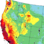
New USGS map shows where the most damaging earthquakes are likely to occur in the US
USGS scientists and our partners recently revealed the latest National Seismic Hazard Model, showing that nearly 75% of the United States could experience a damaging earthquake, emphasizing seismic hazards span a significant part of the country.
Norwegian Microsatellite Developed by Space Flight Laboratory (SFL) Achieves Optical Satellite-to-Ground Communications Link
TORONTO, Ontario, Canada, 31 January 2024 – The NorSat-TD demonstration microsatellite developed by Space Flight Laboratory (SFL) for the Norwegian Space Agency (NOSA) has successfully transferred data to a ground station using optical communications technology. The accomplishment is a first for a Dutch-built laser communication device and among the first achieved by a microsatellite.
SimActive Announces Enhanced Cloud Capabilities
Montreal, Canada, January 23rd, 2024 – SimActive Inc., a world-leading developer of photogrammetry software, announces the enhancement of Correlator3D™ for improved cloud environment productivity. With Correlator3D’s distributed processing capabilities, clients can seamlessly scale their processing in line with operational needs.
Maxar Intelligence Wins NGA Contract for Precision3D Data
WESTMINSTER, Colo.–(BUSINESS WIRE)–Maxar Intelligence, a provider of secure, precise, geospatial intelligence, today announced that it received a contract to provide the National Geospatial-Intelligence Agency (NGA) with a Precision3DTM Data Suite bundle covering 160,000 square kilometers within the U.S. Indo-Pacific Command area of responsibility.
Remote Accounting Success: Tools and Tips for a Thriving Virtual Practice
The concept of remote work has evolved from a temporary solution to a permanent fixture, reshaping the landscape of professional practices. According to McKinsey & Company, 58 percent of Americans now have the opportunity to work from home at least one day a week. This figure takes on even greater significance as 35 percent of […]


