
USGS scientists and our partners recently revealed the latest National Seismic Hazard Model, showing that nearly 75% of the United States could experience a damaging earthquake, emphasizing seismic hazards span a significant part of the country.
Norwegian Microsatellite Developed by Space Flight Laboratory (SFL) Achieves Optical Satellite-to-Ground Communications Link

TORONTO, Ontario, Canada, 31 January 2024 – The NorSat-TD demonstration microsatellite developed by Space Flight Laboratory (SFL) for the Norwegian Space Agency (NOSA) has successfully transferred data to a ground station using optical communications technology. The accomplishment is a first for a Dutch-built laser communication device and among the first achieved by a microsatellite.
SimActive Announces Enhanced Cloud Capabilities

Montreal, Canada, January 23rd, 2024 – SimActive Inc., a world-leading developer of photogrammetry software, announces the enhancement of Correlator3D™ for improved cloud environment productivity. With Correlator3D’s distributed processing capabilities, clients can seamlessly scale their processing in line with operational needs.
The Mesa® 4 Rugged Tablet by Juniper® Systems is now available and shipping worldwide.

Experience rugged computing in any environment.
Maxar Intelligence Wins NGA Contract for Precision3D Data

WESTMINSTER, Colo.–(BUSINESS WIRE)–Maxar Intelligence, a provider of secure, precise, geospatial intelligence, today announced that it received a contract to provide the National Geospatial-Intelligence Agency (NGA) with a Precision3DTM Data Suite bundle covering 160,000 square kilometers within the U.S. Indo-Pacific Command area of responsibility.
Wildfire Preparedness: UP42 and OroraTech Facilitate Geospatial Data Access with On-Demand Sensor Tasking

Berlin/Munich, November 30, 2023 – UP42, a geospatial developer platform and marketplace, and OroraTech, the leader in space-based thermal intelligence, have signed a partnership agreement to grant easy and fast access to global high-resolution thermal-infrared imagery. OroraTech delivers low-latency, global coverage, near-real-time thermal data products.
blackshark.ai Closes an Oversubscribed Extension to its Series A Round, totaling $35 Million

blackshark.ai Closes an Oversubscribed Extension to its Series A Round, totaling $35 Million, to Fast-Track Commercialization of its Unique GEOINT and 3D Mapping Technology.
Esri Integrates with Microsoft Fabric to Deliver Leading Spatial Analytics Capabilities

Esri’s Interactive Mapping and Data Exploration Delivers 140 Spatial Analytics Tools and Functions into the Fabric User Experience
Marine Institute and TCarta Student Internship Program Makes Major Data Contribution to Seabed 2030 Project
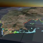
TCarta Marine, a global provider of hydrospatial products and services, has delivered three major satellite derived bathymetry (SDB) data sets to The Nippon Foundation-GEBCO Seabed 2030 project. Students in Canada participating in a 2023 summer internship program created the SDB products for the entire coastline of Madagascar, Newfoundland, and two Canadian Arctic research areas.
Webinar – How to Save Time and Money on Photogrammetry Projects

Webinar on Thursday, November 16th – Hosted by Eric Andelin CP, Senior Workflow Specialist with guest speaker Michael O’Sullivan, VP Sales, SimActive Inc.